Droning On
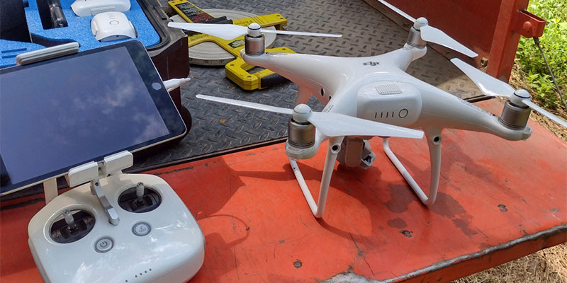
DJ Phantom Drone
When your field lab covers more than 1,500 acres, tracking plant communities can be tedious and time consuming. To chart and document changes in our plant population, we use the power of technology. Since walking is not a practical option, we call on drone camera and GPS data to help us access even the most challenging terrain in a non-invasive way.
Using a drone, study areas can be tracked from the air, which saves time and allows us to monitor the plant population. This is especially beneficial when the area you want to study is hard to access or where study points are hundreds of meters apart. Study from the air also prevents any inadvertent damage to plants and wildlife.
Programmed with a regular, repeatable flight path, we fly our drone over the exact same coordinates each flight, taking detailed high-resolution photos of vegetation from 10 feet off the ground. Our growing library of photos shows changes from week to week, season to season, and year to year — data crucial to shaping our management and conservation strategies. Our long-term goal, particularly with native grassland restoration, is to establish a network of healthy, diverse examples of these once-common ecosystems that are now imperiled.
In addition to identification through the photos, physical identification of plants is also conducted on site in the specific study areas. Currently, each of the six southeastern prairies we are monitoring has five to six study areas that measure 10 x 10 feet.

Examples of individual prairie plants from approximately 5 feet.
To help identify the plants, we use the app Picture This as well as the Flora of the Southeastern United States key written by Alan Weakley and colleagues. Species are additionally documented using a mobile application which records the plant photo, coordinates, altitude, weather, address of location (if applicable), and notes from the field.

Brianna Bergamini, Southern 8ths Field Station Prairie Keeper with drone.
With the help of technology, and staff members we’re able to understand the succession of our prairies, enhance the process of documentation, improve conservation methods, and tell nature’s story. Who knew? Maybe you’d like to be a modern naturalist. It’s almost like getting paid to play video games, but with real results! If you’re interested in using your own drone to study natural habitats, we’d be glad to offer some tips.